What is the Heidelberg Tributary Loading Program?
A tributary loading program measures the “load,” that is, the amount of pollutants that move downstream past a sampling station on a river or creek each year. The tons of pollutants moving past a sampling station represent both the pollutant load to downstream receiving waters, such as Lake Erie or the Ohio River, and the pollutant export from the watershed upstream from the sampling station. Accurate pollutant loading measurements require information on stream flows (cubic feet per second) and frequent pollutant concentration measurements (milligrams per liter) in the water flowing past the sampling station.
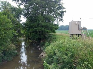
All streamflow measurements used by the Heidelberg Tributary Loading Program (HTLP) are provided by the United States Geological Survey (USGS). Heidelberg University’s National Center for Water Quality Research (NCWQR) collects and analyzes approximately 450-500 water samples for pollutants at each monitoring station each year. From that information, it calculates annual pollutant loads from each station and the loads of nutrients, sediments, and pesticides delivered to Lake Erie or the Ohio River. The loads from tributaries largely determine the nutrient (especially phosphorus) concentrations in lakes that cause harmful algal blooms (HABs). As of 2021, the HTLP includes 21 sampling stations in Ohio and southeastern Michigan. Those stations together permit the calculation of the pollutant export (loads) from over 50% of Ohio’s land area.
What is important about the Heidelberg Tributary Loading Program?
Measurements of pollutant export from watersheds are used to compare the amounts of pollutants derived from diffuse nonpoint sources, such as agricultural and urban storm runoff, with contributions from point sources, such as sewage treatment plants. The Heidelberg Tributary Loading Program (HTLP) was initiated by the NCWQR in 1974 as part of state and federal programs to restore Lake Erie. It is now the longest-term and most detailed program of its kind in the United States. By the end of 2013, more than 142,000 samples from HTLP stations had been analyzed for sediments and nutrients. Thousands of additional samples have been analyzed for agricultural pesticides. Lake Erie tributaries being sampled in 2014 include the Cuyahoga, Maumee (the main stem plus the Blanchard and Tiffin rivers and a branch of Lost Creek), Portage, Raisin (in Michigan), and Sandusky (the main stem and Honey and Rock creeks). Ohio River tributaries being monitored are the Great Miami, Muskingum, and Scioto rivers; and Beaver, Chickasaw and Coldwater creeks in the Grand Lake St. Marys watershed within the Wabash River basin.
Detailed knowledge of concentrations and loads of nutrients and suspended sediment exported through these river systems has added greatly to our understanding of the impacts of rural, largely agricultural land management practices on stream water quality and ultimately the quality of both the Ohio River and Lake Erie. This information has also permitted detection of trends in water quality, especially changes in loads of several forms of phosphorus and nitrogen that greatly influence the development of harmful algal blooms and oxygen-devoid “dead zones” in Lake Erie, inland lakes and reservoirs, and the Gulf of Mexico.
The HTLP is the only program of its type in the Great Lakes Basin. It has made possible the following initiatives and accomplishments:
- The HTLP comprises the primary source of data used to estimate the total annual loading of phosphorus to all of Lake Erie.
- Data from the HTLP was used in the establishment by the Great Lakes Water Quality Agreement of the target annual phosphorus load of 11,000 metric tons for Lake Erie and provided the evidence in the 1980s that the target annual load was being met except for years of high tributary runoff.
- Based on evidence provided by the HTLP that the loading of dissolved reactive phosphorus into Lake Erie began to increase in the mid-1990s at the same time that harmful algal blooms also increased, the interagency Ohio Lake Erie Phosphorus Task Force was formed in 2007 to investigate the causes of that increased loading and to make recommendations to federal and state agencies for counteracting that increase.
- HTLP data enable direct assessment and evaluation of the watershed-scale effectiveness of BMP implementation programs aimed at nutrient load reductions from watersheds to Lake Erie, Grand Lake St. Marys, and the Ohio River.
- Scientists at numerous universities who are developing models linking land uses to Lake Erie water quality rely on HTLP data to calibrate and validate their models. These universities include the University of Michigan, Ohio State University, University of Toledo, Tufts University, University of California Berkeley, University of Wisconsin Green Bay, University of Waterloo in Canada, and others.
- The HTLP network is a crucial component of the newly formed Eastern Corn Belt node of the Long-Term Agro-ecosystem Research program of the USDA Agricultural Research Service (ARS). The node is a partnership of the NCWQR and ARS’s Soil Drainage Research Unit and National Soil Erosion Research Laboratory.
- HTLP data sets are widely accessed by government agencies, educational institutions, commercial organizations and non-profits, and they attract numerous research and implementation grants to Ohio.
